
1951 Map of Miami Station
USGS Topo · Published 1952About this map
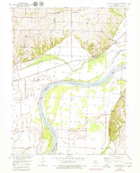
The Missouri River cuts a wide path across this landscape, defining the boundary between Carroll and Saline counties. In the early 1950s, the lowlands south of the river are marked by a complex system of levees protecting the Grand Pass area, including Lake Deteseau and the expansive Van Meter State Park. On the northern side, the Wabash railroad skirts the base of the river bluffs, serving the small hub of Miami Station.
Find a feature on this map
25 named features on this map. Tap any name to fly to it.
Don’t see what you’re looking for? This feature index may not catch every label — zoom into the map to look around manually.
Map Details
Editions of this 1951 Miami Station Map
2 editions found
Other maps of this area

1890 · Marshall
USGS Topo · 1:125,000

1892 · Marshall
USGS Topo · 1:125,000

1901 · Marshall
USGS Topo · 1:125,000

1940 · Marshall
USGS Topo · 1:62,500

1944 · Marshall
USGS Topo · 1:62,500

1951 · Bosworth
USGS Topo · 1:24,000

1951 · Miami
USGS Topo · 1:24,000

1951 · Brunswick West
USGS Topo · 1:24,000

1951 · Carrollton East
USGS Topo · 1:24,000
1951 · Standish
USGS Topo · 1:24,000