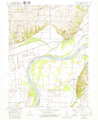
1951 Map of Miami Station
USGS Topo · Published 1979About this map
Van Meter State Park dominates the southeastern quadrant of this map, showcasing the dramatic bluffs overlooking the Missouri River bottomlands. The landscape reflects a mid-century agricultural and transit corridor, where the Wabash railroad cuts across the Wakenda Creek valley toward the settlement of Miami Station. This era shows a high density of small rural landmarks, including a cluster of family-named burial grounds like Adkins Cem and Cannon Cem, alongside community anchors such as Bethlehem Ch and White Rock Sch. The levee systems along the river and creek highlight the persistent engineering required to manage the floodplains of the Missouri River, which forms the winding boundary between Carroll and Saline Counties. Local industry is noted by a Quarry near the rail line, while the presence of Teteseau Lake and Coon Hollow suggests the varied terrain found just beyond the river’s edge.
Find a feature on this map
27 named features on this map. Tap any name to fly to it.
Don’t see what you’re looking for? This feature index may not catch every label — zoom into the map to look around manually.
Map Details
Editions of this 1951 Miami Station Map
2 editions found
Other maps of this area

1890 · Marshall
USGS Topo · 1:125,000

1892 · Marshall
USGS Topo · 1:125,000

1901 · Marshall
USGS Topo · 1:125,000

1940 · Marshall
USGS Topo · 1:62,500

1944 · Marshall
USGS Topo · 1:62,500

1951 · Bosworth
USGS Topo · 1:24,000

1951 · Miami
USGS Topo · 1:24,000

1951 · Brunswick West
USGS Topo · 1:24,000

1951 · Miami Station
USGS Topo · 1:24,000

1951 · Carrollton East
USGS Topo · 1:24,000