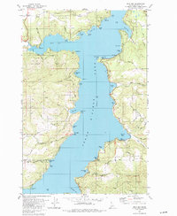
1981 Map of Mica Bay
USGS Topo · Published 1982About this map
Coeur d'Alene Lake defines this section of the Idaho panhandle, its deeply indented shoreline creating a complex network of bays and points. The western shore is dominated by the Mica Bay area, including the Mica Bay County Campground and the agricultural clearing of Mica Flats. Settlement is concentrated at points of water access such as Mica and Goulds Landing, while the southern reaches cross into the Coeur d'Alene Indian Reservation Boundary.
Find a feature on this map
66 named features on this map. Tap any name to fly to it.
Don’t see what you’re looking for? This feature index may not catch every label — zoom into the map to look around manually.
Map Details
Editions of this 1981 Mica Bay Map
This is the sole edition of this map. No revisions or reprints were ever made.
Other maps of this area

1903 · Rathdrum
USGS Topo · 1:125,000

1955 · Spokane
USGS Topo · 1:250,000

1957 · St. Maries
USGS Topo · 1:62,500

1957 · Plummer
USGS Topo · 1:62,500

1957 · Coeur D'Alene
USGS Topo · 1:62,500

1957 · Lane
USGS Topo · 1:62,500

1958 · Spokane
USGS Topo · 1:250,000

1975 · Plummer NW
USGS Topo · 1:24,000

1975 · Coeur D'Alene SE
USGS Topo · 1:24,000

1975 · Plummer NE
USGS Topo · 1:24,000