
2000 Map of Michigan Bluff
USGS Topo · Published 2003About this map
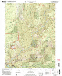
Michigan Bluff serves as the focal point of this Gold Country landscape, situated above the confluence of the Middle Fork American River and North Fork American River. The map documents a dense concentration of historical mining operations, featuring names like Mountain Chief Mine, Bullion Mine, and the Hidden Treasure Mine. These sites, along with several pits and tunnels, reveal the intensive resource extraction that defined the region's economy and shaped its topographic footprint within the Tahoe National Forest.
Find a feature on this map
126 named features on this map. Tap any name to fly to it.
Don’t see what you’re looking for? This feature index may not catch every label — zoom into the map to look around manually.
Map Details
Editions of this 2000 Michigan Bluff Map
2 editions found
Other maps of this area

1891 · Colfax
USGS Topo · 1:125,000

1891 · Placerville
USGS Topo · 1:125,000

1892 · Placerville
USGS Topo · 1:125,000

1892 · Colfax
USGS Topo · 1:125,000

1893 · Placerville
USGS Topo · 1:125,000

1894 · Colfax
USGS Topo · 1:125,000

1898 · Colfax
USGS Topo · 1:125,000

1900 · Colfax
USGS Topo · 1:125,000

1902 · Colfax
USGS Topo · 1:125,000

1938 · Colfax
USGS Topo · 1:125,000