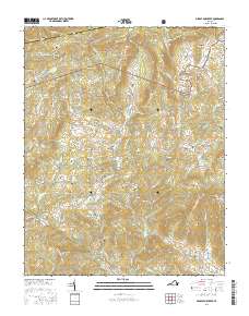
2016 Map of Middle Fox Creek
USGS Topo · Published 2016About this map
Jefferson National Forest dominates the high-country terrain of Grayson and Smyth Counties in this contemporary study of the Blue Ridge Highlands. The Tennessee Valley Divide snakes through the northern portion of the map, marking a critical hydrological boundary near Hemp Patch and Blue Spring Gap. This area is characterized by a dense concentration of family-named cemeteries and landmarks, suggesting a long-standing settlement pattern tucked between the steep ridges of Brushy Ridge and Nettle Ridge. The community of Flat Ridge serves as a focal point in a landscape drained by the complex network of Middle Fox Creek and its many branches. Genealogists will find a wealth of local history through dozens of site-specific labels, from Burton Chapel Cem to the Holdaway Cem, illustrating the deep ties between the people and these remote mountain hollows.
Find a feature on this map
125 named features on this map. Tap any name to fly to it.
Don’t see what you’re looking for? This feature index may not catch every label — zoom into the map to look around manually.
Map Details
Editions of this 2016 Middle Fox Creek Map
This is the sole edition of this map. No revisions or reprints were ever made.
Other maps of this area

1889 · Wytheville
USGS Topo · 1:125,000

1892 · Wytheville
USGS Topo · 1:125,000

1930 · Speedwell
USGS Topo · 1:62,500

1930 · Independence
USGS Topo · 1:48,000

1931 · Rural Retreat
USGS Topo · 1:48,000

1933 · Independence
USGS Topo · 1:62,500

1935 · Mouth of Wilson
USGS Topo · 1:48,000

1935 · Cedar Springs
USGS Topo · 1:24,000
1935 · Trout Dale
USGS Topo · 1:24,000
1935 · Atkins
USGS Topo · 1:24,000