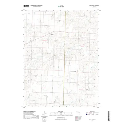
2017 Map of Middle Grove
USGS Topo · Published 2017About this map
The Randolph Co Monroe Co boundary bisects this agricultural landscape, where the Elk Fork Salt River and its many tributaries, including Coon Cr and Milligan Cr, carve a network of drainages through the central Missouri plains. The settlement pattern remains largely dispersed, anchored by the crossroads of Evansville and the community of Middle Grove. These small rural centers, along with the hamlet of Milton, serve as focal points for a region defined by its waterway-carved topography and a dense grid of county roads such as Co RD 121. Family history is preserved in small burial grounds like Cottingham Cem and Meals Cem, while the inclusion of Irons Airport and Johnson Lake indicates the modern infrastructure of the early 21st century. The map provides a detailed view of the rural landscape before major suburban shifts, showing the persistent value of small-scale aviation and local water management in the Midwest.
Find a feature on this map
67 named features on this map. Tap any name to fly to it.
Don’t see what you’re looking for? This feature index may not catch every label — zoom into the map to look around manually.
Map Details
Editions of this 2017 Middle Grove Map
This is the sole edition of this map. No revisions or reprints were ever made.
Other maps of this area

1890 · Moberly
USGS Topo · 1:125,000

1908 · Macon
USGS Topo · 1:62,500

1910 · Macon
USGS Topo · 1:62,500

1952 · Middle Grove
USGS Topo · 1:24,000

1953 · Moberly
USGS Topo · 1:250,000

1953 · Renick
USGS Topo · 1:24,000

1953 · Clark
USGS Topo · 1:24,000
1953 · Moberly
USGS Topo · 1:24,000

1954 · Moberly
USGS Topo · 1:250,000

1957 · Moberly
USGS Topo · 1:250,000