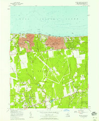
1956 Map of Middle Island
USGS Topo · Published 1958About this map
Long Island Sound borders the northern reaches of this mid-century Suffolk County landscape, where the settlements of Sound Beach and Rocky Point show established residential grids. Moving inland, the terrain transitions into the wooded expanses of Brookhaven, characterized by a complex network of historic transit routes including North Country Road, Whiskey Road, and an Old RR Grade. The map captures a moment when large institutional footprints were becoming prominent, such as the U S Reservation Brookhaven National Laboratory and the Middle Island Game Farm.
Find a feature on this map
66 named features on this map. Tap any name to fly to it.
Don’t see what you’re looking for? This feature index may not catch every label — zoom into the map to look around manually.
Map Details
Editions of this 1956 Middle Island Map
This is the sole edition of this map. No revisions or reprints were ever made.
Other maps of this area

1891 · Bridgeport
USGS Topo · 1:62,500

1893 · Bridgeport
USGS Topo · 1:62,500

1902 · Setauket
USGS Topo · 1:62,500

1904 · Setauket
USGS Topo · 1:62,500

1904 · Islip
USGS Topo · 1:125,000

1904 · Moriches
USGS Topo · 1:62,500

1919 · Setauket
USGS Topo · 1:62,500

1920 · Bridgeport
USGS Topo · 1:62,500

1942 · Islip
USGS Topo · 1:125,000

1947 · Bellport
USGS Topo · 1:24,000