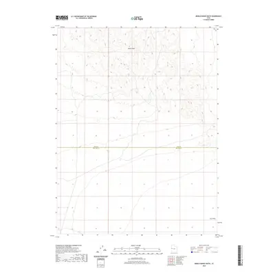
2020 Map of Middle Range South
USGS Topo · Published 2020About this map
The Middle Range dominates the northern terrain of this Millard County landscape, characterized by its intricate contour patterns and significant elevation shifts. This survey captures a transition from the highlands into the broad expanse of Tule Valley to the southeast, where the topography levels into a wide basin floor. The isolation of this region is underscored by the presence of only a single primary roadway, the Weis Hwy, which skirts the northeastern corner of the map. Straddling the boundary between Juab and Millard counties, the map illustrates the geological structure of Utah’s west-central desert before modern development. The absence of traditional settlements or townships emphasizes the area's role as part of the Great Basin's interior, where land use is primarily defined by the natural environment and administrative boundaries.
Find a feature on this map
4 named features on this map. Tap any name to fly to it.
Don’t see what you’re looking for? This feature index may not catch every label — zoom into the map to look around manually.
Map Details
Editions of this 2020 Middle Range South Map
This is the sole edition of this map. No revisions or reprints were ever made.
Other maps of this area

1908 · Fish Springs
USGS Topo · 1:250,000

1910 · Fish Springs
USGS Topo · 1:250,000

1953 · Delta
USGS Topo · 1:250,000

1958 · Delta
USGS Topo · 1:250,000

1959 · Cowboy Pass
USGS Topo · 1:62,500

1960 · Granite Mountain
USGS Topo · 1:62,500

1962 · Delta
USGS Topo · 1:250,000

1967 · Sand Pass
USGS Topo · 1:24,000

1967 · Sand Pass NW
USGS Topo · 1:24,000
1972 · Swasey Peak NW
USGS Topo · 1:24,000