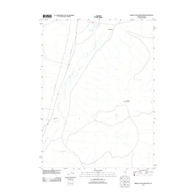
2012 Map of Middle Stack Mountain
USGS Topo · Published 2012About this map
Salmon Falls Creek carves a winding path through this high-desert landscape of Elko County, defining the western drainage patterns of the region. The map documents a landscape primarily dedicated to ranching and water resources, centered on the historic San Jacinto Ranch and the nearby settlement of San Jacinto. The presence of several distinct water sources, including Mineral Hot Spring, San Jacinto Ranch Spring, and Aspen Spring, highlights the critical importance of riparian zones in this arid environment. To the east, the topography rises toward the prominent Middle Stack Mountain, while transport history is preserved in the alignment of Old Hwy 93 and Old US Hwy 93, which parallel the creek. Further south, Middle Stacks Ranch serves as another focal point of human habitation along the Meadow Creek drainage.
Find a feature on this map
11 named features on this map. Tap any name to fly to it.
Don’t see what you’re looking for? This feature index may not catch every label — zoom into the map to look around manually.
Map Details
Editions of this 2012 Middle Stack Mountain Map
This is the sole edition of this map. No revisions or reprints were ever made.
Other maps of this area

1955 · Wells
USGS Topo · 1:250,000

1957 · Contact
USGS Topo · 1:62,500

1957 · Delaplain
USGS Topo · 1:62,500

1958 · Wells
USGS Topo · 1:250,000

1961 · Wells
USGS Topo · 1:250,000

1968 · Henry
USGS Topo · 1:24,000

1968 · Blanchard Mtn
USGS Topo · 1:24,000

1968 · Texas Spring
USGS Topo · 1:24,000

1982 · Jackpot
USGS Topo · 1:100,000
1989 · Jackpot
USGS Topo · 1:24,000