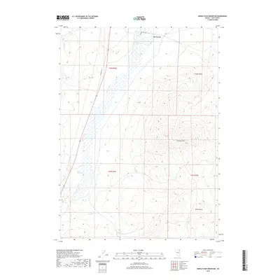
2018 Map of Middle Stack Mountain
USGS Topo · Published 2018About this map
San Jacinto serves as a lone point of settlement in this 2018 survey of Elko County's high desert terrain. The landscape is defined by the significant drainage of Salmon Falls Cr, which creates a riparian corridor through the sagebrush flats and volcanic uplands. This area shows evidence of geothermal activity at Mineral Hot Spring, while the hydrology of the ranching country is further supported by San Jacinto Ranch Spring and Aspen Spring. To the east, the topography rises sharply into the high peaks of Mid Stack Mtn and the northern reaches of the Granite Range. Transportation is focused on the corridor of Old Hwy US 93 and San Jacinto Rd, which navigate the elevation changes between the creek valley and the surrounding mountains.
Find a feature on this map
14 named features on this map. Tap any name to fly to it.
Don’t see what you’re looking for? This feature index may not catch every label — zoom into the map to look around manually.
Map Details
Editions of this 2018 Middle Stack Mountain Map
This is the sole edition of this map. No revisions or reprints were ever made.
Other maps of this area

1955 · Wells
USGS Topo · 1:250,000

1957 · Contact
USGS Topo · 1:62,500

1957 · Delaplain
USGS Topo · 1:62,500

1958 · Wells
USGS Topo · 1:250,000

1961 · Wells
USGS Topo · 1:250,000

1968 · Henry
USGS Topo · 1:24,000

1968 · Blanchard Mtn
USGS Topo · 1:24,000

1968 · Texas Spring
USGS Topo · 1:24,000

1982 · Jackpot
USGS Topo · 1:100,000
1989 · Jackpot
USGS Topo · 1:24,000