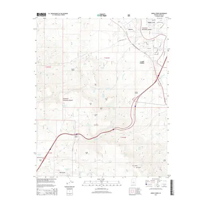
2014 Map of Middle Verde
USGS Topo · Published 2014About this map
Coconino National Forest and Prescott National Forest converge in this high-desert landscape near Camp Verde. The terrain is defined by the sharp descent from the Black Hills through Copper Canyon and Gaddis Canyon toward the Verde River valley. Historic ranching and irrigation infrastructure is evident through numerous upland water catchments like Oxtail Tank and Mistake Tank, as well as the Ok Ditch system near Middle Verde. Small settlements and named locales such as Aultman and Flower Pot are situated along the primary transit corridors, including Old Hwy 279 and the Camp Verde Bridgeport Hwy. Genealogists will find the Mid Verde Cem positioned near the northern edge of the map, while geological landmarks like Table Mtn and Grief Hill provide clear orientation for the surrounding drainage basins of Cienega Cr and Gaddis Wash.
Find a feature on this map
69 named features on this map. Tap any name to fly to it.
Don’t see what you’re looking for? This feature index may not catch every label — zoom into the map to look around manually.
Map Details
Editions of this 2014 Middle Verde Map
This is the sole edition of this map. No revisions or reprints were ever made.
Other maps of this area

1887 · Verde
USGS Topo · 1:250,000

1887 · Prescott
USGS Topo · 1:250,000

1892 · Verde
USGS Topo · 1:250,000

1892 · Prescott
USGS Topo · 1:250,000

1903 · Bradshaw Mountains
USGS Topo · 1:125,000

1905 · Jerome
USGS Topo · 1:125,000

1923 · Camp Verde
USGS Topo · 1:125,000

1929 · Turret Peak
USGS Topo · 1:125,000

1932 · Camp Verde
USGS Topo · 1:125,000

1933 · Turret Peak
USGS Topo · 1:125,000