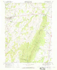
1968 Map of Middleburg
USGS Topo · Published 1970About this map
The Bull Run Mountains dominate the southeastern landscape of this 1968 survey, forming a natural boundary between Loudoun and Prince William counties. This area of Northern Virginia is defined by its traditional equestrian and agrarian character, exemplified by the Glenwood Racetrack north of Middleburg. The settlement pattern follows the Little River and Goose Creek, where established communities like Aldie, Dover, and Stoke are situated.
Find a feature on this map
50 named features on this map. Tap any name to fly to it.
Don’t see what you’re looking for? This feature index may not catch every label — zoom into the map to look around manually.
Map Details
Editions of this 1968 Middleburg Map
3 editions found
Other maps of this area

1884 · Harpers Ferry
USGS Topo · 1:125,000

1891 · Harpers Ferry
USGS Topo · 1:125,000

1893 · Harpers Ferry
USGS Topo · 1:125,000

1894 · Warrenton
USGS Topo · 1:125,000

1916 · Berryville
USGS Topo · 1:62,500

1933 · Middleburg
USGS Topo · 1:62,500

1939 · Berryville
USGS Topo · 1:48,000

1943 · Arcola
USGS Topo · 1:24,000

1943 · Bluemont
USGS Topo · 1:24,000

1943 · Thorofare Gap
USGS Topo · 1:24,000