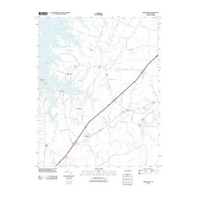
2010 Map of Middleburg
USGS Topo · Published 2010About this map
Middleburg and Manson serve as primary anchors for this area of Vance County, characterized by a mix of established rural settlements and the development around John H Kerr Reservoir. The landscape is defined by the reservoir's fingers extending into the terrain, creating prominent points like Satterwhite Point and supporting local recreation at sites such as Tarheel Marina. The presence of Soul City on the eastern edge of the map highlights a unique chapter in late-century planned community history, while more traditional hubs like Bullocksville and Drewry remain connected by a network of rural routes. Throughout the area, local history is preserved in sites like Ridgeway Cemetery and Mount Pleasant Cemetery, which stand alongside water features like Peetes Pond and the headwaters of Fishing Creek.
Find a feature on this map
66 named features on this map. Tap any name to fly to it.
Don’t see what you’re looking for? This feature index may not catch every label — zoom into the map to look around manually.
Map Details
Editions of this 2010 Middleburg Map
This is the sole edition of this map. No revisions or reprints were ever made.
Other maps of this area

1953 · Greensboro
USGS Topo · 1:250,000

1954 · Greensboro
USGS Topo · 1:250,000

1955 · Boydton
USGS Topo · 1:62,500

1962 · Greensboro
USGS Topo · 1:250,000

1966 · Greensboro
USGS Topo · 1:250,000

1968 · Bracey
USGS Topo · 1:24,000
1968 · Tungsten
USGS Topo · 1:24,000

1968 · John H Kerr Dam
USGS Topo · 1:24,000

1970 · Vicksboro
USGS Topo · 1:24,000
1970 · Middleburg
USGS Topo · 1:24,000