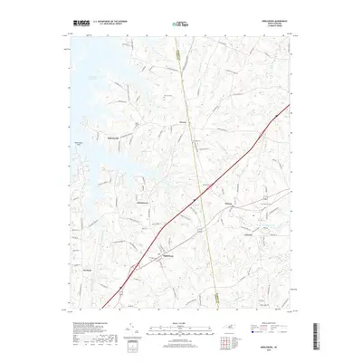
2019 Map of Middleburg
USGS Topo · Published 2019About this map
Middleburg and the surrounding borderlands of Vance and Warren Counties are defined by a mix of agricultural history and modern water management. The northwestern corner is dominated by the expanse of the John H. Kerr Reservoir, where Satterwhite Point extends into the water near the settlement of Bullocksville. This modern landscape is overlaid upon a network of rural communities such as Manson and Drewry, and the planned community of Soul City located near the eastern edge of the quadrangle. Genealogists will find a cluster of community burial grounds across the area, including Mount Pleasant Cem, New Hope Cem, and Oak Level Cem. The terrain is characterized by numerous small drainage systems like Fishing Cr and Ellington Br, which dictate the winding paths of local roads such as Allison Cooper Rd and Burchette Chapel Rd.
Find a feature on this map
103 named features on this map. Tap any name to fly to it.
Don’t see what you’re looking for? This feature index may not catch every label — zoom into the map to look around manually.
Map Details
Editions of this 2019 Middleburg Map
This is the sole edition of this map. No revisions or reprints were ever made.
Other maps of this area

1953 · Greensboro
USGS Topo · 1:250,000

1954 · Greensboro
USGS Topo · 1:250,000

1955 · Boydton
USGS Topo · 1:62,500

1962 · Greensboro
USGS Topo · 1:250,000

1966 · Greensboro
USGS Topo · 1:250,000

1968 · Bracey
USGS Topo · 1:24,000
1968 · Tungsten
USGS Topo · 1:24,000

1968 · John H Kerr Dam
USGS Topo · 1:24,000

1970 · Vicksboro
USGS Topo · 1:24,000
1970 · Middleburg
USGS Topo · 1:24,000