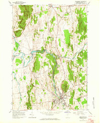
1963 Map of Middlebury
USGS Topo · Published 1964About this map
Otter Creek carves a winding path through the heart of this Addison County landscape, defining the industrial and agricultural development of Middlebury and its surrounding townships. The waterway supports essential infrastructure such as the Huntington Falls Dam and several powerplants, while the eastern hills are dominated by landmarks like Chipman Hill and the Marble Ledge. This 1960s survey illustrates a region where academic and agricultural tradition meet, most notably at the Univ of Vermont Morgan Horse Farm near Weybridge Hill. Transportation is centered on the Vermont Railway corridor, which connects New Haven Junction with the bustling center of Middlebury. The map is particularly rich for genealogical research, documenting numerous burial grounds including the Old Middlebury Cem, St Marys Cem, and the more secluded Brittle Azra Stow Cem.
Find a feature on this map
48 named features on this map. Tap any name to fly to it.
Don’t see what you’re looking for? This feature index may not catch every label — zoom into the map to look around manually.
Map Details
Editions of this 1963 Middlebury Map
3 editions found
Other maps of this area

1894 · Port Henry
USGS Topo · 1:62,500

1894 · Ticonderoga
USGS Topo · 1:62,500

1896 · Ticonderoga
USGS Topo · 1:62,500

1898 · Port Henry
USGS Topo · 1:62,500

1902 · Ticonderoga
USGS Topo · 1:62,500

1902 · Brandon
USGS Topo · 1:62,500

1903 · Middlebury
USGS Topo · 1:62,500

1904 · Brandon
USGS Topo · 1:62,500

1905 · Middlebury
USGS Topo · 1:62,500

1920 · Brandon
USGS Topo · 1:62,500