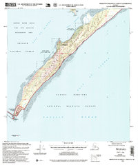
1995 Map of Middleton Island D-1 and D-2
USGS Topo · Published 1999About this map
Kayak Island serves as a narrow sentinel between the Kayak Entrance and the open Gulf of Alaska in this late 20th-century survey. The landscape is defined by its protective status, dominated by the Chugach National Forest and the Alaska Maritime National Wildlife Refuge. Historical and maritime significance is concentrated at the island's southern tip at Cape Saint Elias, where the Cape Saint Elias Lighthouse Reserve and a Communication Tower stand near the iconic Pinnacle Rock.
Find a feature on this map
29 named features on this map. Tap any name to fly to it.
Don’t see what you’re looking for? This feature index may not catch every label — zoom into the map to look around manually.
Map Details
Editions of this 1995 Middleton Island D-1 and D-2 Map
This is the sole edition of this map. No revisions or reprints were ever made.
Other maps of this area

1948 · Cordova
USGS Topo · 1:250,000

1948 · Middleton Island
USGS Topo · 1:250,000

1950 · Middleton Island
USGS Topo · 1:250,000

1950 · Cordova A-1
USGS Topo · 1:63,360

1950 · Cordova A-2
USGS Topo · 1:63,360

1951 · Cordova
USGS Topo · 1:250,000

1953 · Cordova A-2
USGS Topo · 1:63,360
1953 · Cordova A-1
USGS Topo · 1:63,360
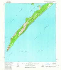
1955 · Middleton Island D-1 and D-2
USGS Topo · 1:63,360
1955 · Middleton Island
USGS Topo · 1:250,000