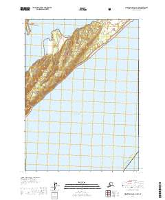
2017 Map of Middleton Island D-1 NW
USGS Topo · Published 2017About this map
Kayak Island dominates the topography of this 2017 survey, situated within the Valdez-Cordova Census Area of Alaska. Reaching out into the Gulf of Alaska, the island represents a pristine example of the state's coastal wilderness. The map illustrates the northern reaches of the island where it meets the Kayak Entrance, a passage critical for navigating these northern waters. Much of the terrain falls under federal protection, shared between the Chugach National Forest and the Alaska Maritime National Wildlife Refuge. This 7.5-minute series map provides a high level of detail for the island's elevation and coastline, offering a valuable record for researchers interested in the environmental preservation and geographic layout of this remote region in the early 21st century.
Find a feature on this map
9 named features on this map. Tap any name to fly to it.
Don’t see what you’re looking for? This feature index may not catch every label — zoom into the map to look around manually.
Map Details
Editions of this 2017 Middleton Island D-1 NW Map
This is the sole edition of this map. No revisions or reprints were ever made.
Other maps of this area

1948 · Cordova
USGS Topo · 1:250,000

1948 · Middleton Island
USGS Topo · 1:250,000

1950 · Middleton Island
USGS Topo · 1:250,000

1950 · Cordova A-1
USGS Topo · 1:63,360

1950 · Cordova A-2
USGS Topo · 1:63,360

1951 · Cordova
USGS Topo · 1:250,000

1953 · Cordova A-2
USGS Topo · 1:63,360
1953 · Cordova A-1
USGS Topo · 1:63,360
1955 · Middleton Island D-1 and D-2
USGS Topo · 1:63,360
1955 · Middleton Island
USGS Topo · 1:250,000