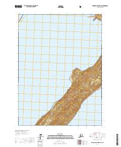
2017 Map of Middleton Island D-2 NE
USGS Topo · Published 2017About this map
Kayak Island dominates the southeastern portion of this coastal survey, its elongated profile rising sharply from the Gulf of Alaska. Much of the landmass is protected within the Chugach National Forest, where steep, high-elevation contours trace the island's narrow central spine. The map documents the primary passage of Kayak Entrance to the north, separating the island from the mainland and surrounding waters. Positioned within the Alaska Valdez-Cordova Census Area, the landscape is defined by its isolation and the dramatic elevation changes that occur within a short distance of the shoreline. The inclusion of the Public Land Survey System grids, such as t22s r5e and t23s r6e, provides a precise framework for locating specific coastal features and terrain markers across this maritime environment.
Find a feature on this map
9 named features on this map. Tap any name to fly to it.
Don’t see what you’re looking for? This feature index may not catch every label — zoom into the map to look around manually.
Map Details
Editions of this 2017 Middleton Island D-2 NE Map
This is the sole edition of this map. No revisions or reprints were ever made.
Other maps of this area

1948 · Cordova
USGS Topo · 1:250,000

1948 · Middleton Island
USGS Topo · 1:250,000

1950 · Middleton Island
USGS Topo · 1:250,000

1950 · Cordova A-1
USGS Topo · 1:63,360

1950 · Cordova A-2
USGS Topo · 1:63,360

1951 · Cordova
USGS Topo · 1:250,000

1953 · Cordova A-2
USGS Topo · 1:63,360
1953 · Cordova A-1
USGS Topo · 1:63,360
1955 · Middleton Island D-1 and D-2
USGS Topo · 1:63,360
1955 · Middleton Island
USGS Topo · 1:250,000