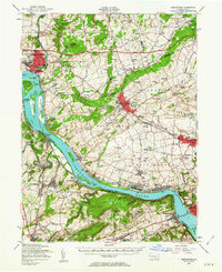
1956 Map of Middletown
USGS Topo · Published 1963About this map
The Susquehanna River dominates this landscape, serving as the broad dividing line between the growing boroughs of Middletown, Mount Joy, and Marietta. In the mid-1950s, the river is dotted with significant landforms like Threemile Island and Shelley Island, while the industrial and military presence at Olmsted AFB marks the northwestern edge. The era's transportation network is clearly defined by the Pennsylvania Turnpike cutting across the northern reaches and the established routes of the Pennsylvania and Reading railroads supporting local commerce.
Find a feature on this map
145 named features on this map. Tap any name to fly to it.
Don’t see what you’re looking for? This feature index may not catch every label — zoom into the map to look around manually.
Map Details
Editions of this 1956 Middletown Map
2 editions found
Other maps of this area

1891 · Lebanon
USGS Topo · 1:62,500

1892 · Hummelstown
USGS Topo · 1:62,500

1892 · Harrisburg
USGS Topo · 1:62,500

1893 · Lebanon
USGS Topo · 1:62,500

1899 · Lebanon
USGS Topo · 1:62,500

1899 · Harrisburg
USGS Topo · 1:62,500

1902 · Lancaster
USGS Topo · 1:62,500

1904 · Lancaster
USGS Topo · 1:62,500

1906 · New Cumberland
USGS Topo · 1:62,500

1908 · Middletown
USGS Topo · 1:62,500