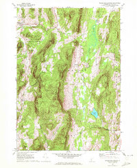
1967 Map of Middletown Springs
USGS Topo · Published 1972About this map
Middletown Springs serves as the focal point of this Rutland County landscape, situated at the confluence of several upland brooks including North Brook and South Brook. The topography is dominated by the massive ridge of Tinmouth Mountain, which separates the drainage of the Poultney River from the expansive wetland system of the Tinmouth Channel. This valley floor contains Chipman Lake and was historically vital for agricultural drainage and local industry.
Find a feature on this map
46 named features on this map. Tap any name to fly to it.
Don’t see what you’re looking for? This feature index may not catch every label — zoom into the map to look around manually.
Map Details
Editions of this 1967 Middletown Springs Map
3 editions found
Other maps of this area

1891 · Rutland
USGS Topo · 1:62,500

1893 · Wallingford
USGS Topo · 1:62,500

1893 · Rutland
USGS Topo · 1:62,500

1894 · Pawlet
USGS Topo · 1:62,500

1895 · Castleton
USGS Topo · 1:62,500

1897 · Pawlet
USGS Topo · 1:62,500

1897 · Castleton
USGS Topo · 1:62,500

1903 · Mettawee
USGS Topo · 1:125,000

1950 · Glens Falls
USGS Topo · 1:250,000

1955 · Wallingford
USGS Topo · 1:62,500