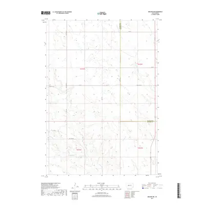
2017 Map of Midland NW
USGS Topo · Published 2017About this map
The high plains of the South Dakota interior are defined by the convergence of the Haakon Co and Stanley Co boundaries in this 2017 survey. The landscape is dominated by a drainage network that feeds into the Mitchell Cr and Lone Tree Cr systems, illustrating the essential relationship between water and land use in this semi-arid region. A grid of section-line roads and named thoroughfares like Saddle Butte Rd and Dusty Ridge Rd provides the primary infrastructure for the ranching and agricultural operations scattered across the quadrangle.
Find a feature on this map
19 named features on this map. Tap any name to fly to it.
Don’t see what you’re looking for? This feature index may not catch every label — zoom into the map to look around manually.
Map Details
Editions of this 2017 Midland NW Map
This is the sole edition of this map. No revisions or reprints were ever made.
Other maps of this area

1954 · Midland
USGS Topo · 1:24,000

1954 · Nowlin
USGS Topo · 1:24,000

1954 · Midland SE
USGS Topo · 1:24,000

1954 · Pierre
USGS Topo · 1:250,000

1958 · Pierre
USGS Topo · 1:250,000

1982 · Hayes South
USGS Topo · 1:24,000
1982 · Midland NE
USGS Topo · 1:24,000

1982 · Midland NW
USGS Topo · 1:24,000

1982 · May Ranch
USGS Topo · 1:24,000

1983 · Philip
USGS Topo · 1:100,000