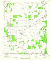
1965 Map of Midnight
USGS Topo · Published 1966About this map
The alluvial landscape of Humphreys County in the mid-1960s is defined by its drainage patterns and the Illinois Central railroad corridor. The small settlement of Midnight sits at a critical junction where the rail line crosses Silver Creek, supported by a nearby substation and the Louise Landing Strip to the south. This era shows a rural community organized around small churches and local institutions, including Mount Vernon Ch, Love Crest Ch, and Mt Zion Ch, alongside the Riven Oak Sch.
Find a feature on this map
19 named features on this map. Tap any name to fly to it.
Don’t see what you’re looking for? This feature index may not catch every label — zoom into the map to look around manually.
Map Details
Editions of this 1965 Midnight Map
This is the sole edition of this map. No revisions or reprints were ever made.
Other maps of this area

1940 · Auter
USGS Topo · 1:62,500

1940 · Mileston
USGS Topo · 1:62,500

1953 · Greenwood
USGS Topo · 1:250,000

1954 · Mileston
USGS Topo · 1:62,500

1955 · Jackson
USGS Topo · 1:250,000

1956 · Greenwood
USGS Topo · 1:250,000

1961 · Jackson
USGS Topo · 1:250,000

1961 · Bayland
USGS Topo · 1:62,500

1961 · Valley
USGS Topo · 1:62,500

1962 · Jackson
USGS Topo · 1:250,000