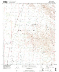
1996 Map of Midway
USGS Topo · Published 2000About this map
The Barry M Goldwater Air Force Range dominates this desert landscape in the late 1990s, where vast stretches of training grounds meet the rising peaks of the Sauceda Mountains. The settlement of Midway sits at the southern edge of the sheet, positioned near a network of benchmarks and desert tracks. The terrain is defined by dry washes and prominent topographic high points such as Lookout Mountain in the northeast.
Find a feature on this map
11 named features on this map. Tap any name to fly to it.
Don’t see what you’re looking for? This feature index may not catch every label — zoom into the map to look around manually.
Map Details
Editions of this 1996 Midway Map
This is the sole edition of this map. No revisions or reprints were ever made.
Other maps of this area

1950 · Theba
USGS Topo · 1:62,500

1951 · Gila Bend
USGS Topo · 1:62,500

1951 · Theba
USGS Topo · 1:62,500

1953 · Ajo
USGS Topo · 1:250,000

1957 · Ajo
USGS Topo · 1:250,000

1958 · Ajo
USGS Topo · 1:250,000

1958 · Midway
USGS Topo · 1:62,500

1958 · Hat Mountain
USGS Topo · 1:62,500

1962 · Ajo
USGS Topo · 1:250,000

1963 · Ajo
USGS Topo · 1:250,000