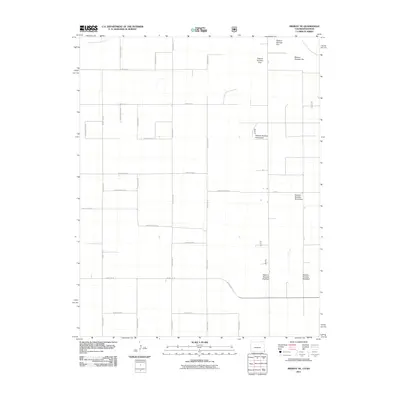
2011 Map of Midway NE
USGS Topo · Published 2011About this map
The North Fork Cimarron River cuts across the extreme northeast corner of this high plains landscape, where the borders of Colorado and Kansas meet. This quadrangle is defined by the rigid, sprawling geometry of the Cimarron National Grassland, organized into numbered parcels such as Pasture Number Fortyseven and Pasture Number Seventeen. The terrain is almost entirely rural and agricultural, characterized by a meticulously planned grid of section-line roads. Major thoroughfares like County Road T and County Rd M facilitate movement through this remote ranching and grazing country. The presence of specialized designations like P Blvd and various local routes such as County Rd 55 illustrate the infrastructure required to manage these extensive grassland allotments during the early twenty-first century.
Find a feature on this map
29 named features on this map. Tap any name to fly to it.
Don’t see what you’re looking for? This feature index may not catch every label — zoom into the map to look around manually.
Map Details
Editions of this 2011 Midway NE Map
This is the sole edition of this map. No revisions or reprints were ever made.
Other maps of this area

1892 · Vilas
USGS Topo · 1:125,000

1955 · La Junta
USGS Topo · 1:250,000

1955 · Dodge City
USGS Topo · 1:250,000

1958 · La Junta
USGS Topo · 1:250,000

1958 · Dodge City
USGS Topo · 1:250,000

1959 · Dodge City
USGS Topo · 1:250,000

1968 · La Junta
USGS Topo · 1:250,000
1973 · Elkhart North
USGS Topo · 1:24,000
1973 · Richfield SW
USGS Topo · 1:24,000
1973 · Elkhart NW
USGS Topo · 1:24,000