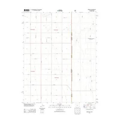
2013 Map of Midway NE
USGS Topo · Published 2013About this map
The Colorado-Kansas state line bisects this high plains landscape, where the open expanses of the Cimarron National Grassland meet a structured grid of rural transit. In the northern reaches, the North Fork Cimarron River carves a subtle path through the terrain, providing the primary hydrological feature in an otherwise dry agricultural and grazing region. The map reveals a strictly organized section line road system, with routes such as Co Road T, Co Road R, and Co Road M defining the boundaries of local landholdings. This survey reflects the modern management of public grasslands and the enduring geometric precision of the Public Land Survey System across the state border.
Find a feature on this map
25 named features on this map. Tap any name to fly to it.
Don’t see what you’re looking for? This feature index may not catch every label — zoom into the map to look around manually.
Map Details
Editions of this 2013 Midway NE Map
This is the sole edition of this map. No revisions or reprints were ever made.
Other maps of this area

1892 · Vilas
USGS Topo · 1:125,000

1955 · La Junta
USGS Topo · 1:250,000

1955 · Dodge City
USGS Topo · 1:250,000

1958 · La Junta
USGS Topo · 1:250,000

1958 · Dodge City
USGS Topo · 1:250,000

1959 · Dodge City
USGS Topo · 1:250,000

1968 · La Junta
USGS Topo · 1:250,000
1973 · Elkhart North
USGS Topo · 1:24,000
1973 · Richfield SW
USGS Topo · 1:24,000
1973 · Elkhart NW
USGS Topo · 1:24,000