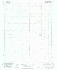
1978 Map of Midway NE
USGS Topo · Published 1978About this map
The Cimarron River cuts through the northern reaches of this High Plains landscape, where the state line divides the rural expanses of Colorado and Kansas. This late 1970s survey documents a region defined by energy extraction and remote infrastructure, specifically within the Baca and Morton County borderlands. The map reveals an extensive network of pipelines, numerous Gas Wells, and Oil Wells that fueled the local economy. In the eastern townships of Westola and Jones, scattered landmarks like the Taloga School and a Radio Tower provide rare points of human assembly. A remote Landing Strip and multiple Pumping Stations further illustrate the specialized industrial character of this prairie environment during a period of active resource development.
Find a feature on this map
13 named features on this map. Tap any name to fly to it.
Don’t see what you’re looking for? This feature index may not catch every label — zoom into the map to look around manually.
Map Details
Editions of this 1978 Midway NE Map
This is the sole edition of this map. No revisions or reprints were ever made.
Other maps of this area

1892 · Vilas
USGS Topo · 1:125,000

1955 · La Junta
USGS Topo · 1:250,000

1955 · Dodge City
USGS Topo · 1:250,000

1958 · La Junta
USGS Topo · 1:250,000

1958 · Dodge City
USGS Topo · 1:250,000

1959 · Dodge City
USGS Topo · 1:250,000

1968 · La Junta
USGS Topo · 1:250,000
1973 · Elkhart North
USGS Topo · 1:24,000
1973 · Richfield SW
USGS Topo · 1:24,000
1973 · Elkhart NW
USGS Topo · 1:24,000