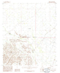
1986 Map of Midway NW
USGS Topo · Published 1986About this map
Luke Air Force Range dominates this mid-1980s landscape, illustrating the intersection of military training grounds and the arid Sonoran desert. The terrain is defined by the sharp elevations of the Crater Range in the southwest, giving way to the alluvial flats of the Midway Wash. This area is characterized by tactical infrastructure, including an Observation Tower and a Heliport, positioned to overlook the sprawling range. The sparse water resources, represented by labels like Black Tank and a single Well, underscore the environmental challenges of this Maricopa County interior. As a provisional edition, this map focuses on terrain relief and military landmarks, preserving the layout of the range before modern expansions. Prominent landmarks like Malpais Hill serve as distinct navigational markers within the vast, open desert environment.
Find a feature on this map
10 named features on this map. Tap any name to fly to it.
Don’t see what you’re looking for? This feature index may not catch every label — zoom into the map to look around manually.
Map Details
Editions of this 1986 Midway NW Map
This is the sole edition of this map. No revisions or reprints were ever made.
Other maps of this area

1949 · Sentinel
USGS Topo · 1:62,500

1950 · Sentinel
USGS Topo · 1:62,500

1950 · Theba
USGS Topo · 1:62,500

1951 · Theba
USGS Topo · 1:62,500

1953 · Ajo
USGS Topo · 1:250,000

1957 · Ajo
USGS Topo · 1:250,000

1958 · Ajo
USGS Topo · 1:250,000

1958 · Midway
USGS Topo · 1:62,500

1962 · Ajo
USGS Topo · 1:250,000

1963 · Ajo
USGS Topo · 1:250,000