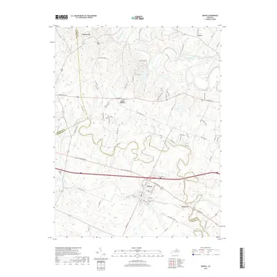
2019 Map of Midway
USGS Topo · Published 2019About this map
Midway sits as the central hub of this Bluegrass region landscape, where the town grid is anchored by Midway Coll and surrounded by the winding courses of North Elkhorn Creek and South Elkhorn Creek. The 2019 survey delineates a transition from suburban development to the traditional horse-country terrain defined by large parcels and historical road networks like Iron Works Rd and W Leestown Pike. Small clusters of settlement such as White Sulphur, Davistown, and Watkinsville remain distinct among the limestone-rich topography. Notable hydrologic and geological features like Big Spring and Simms Sink indicate the karst nature of the Kentucky interior. The map clearly shows the political intersection of three counties, with boundaries for Franklin, Scott, and Woodford counties meeting amidst the creek valleys and the elevated stretch of Pea Ridge.
Find a feature on this map
80 named features on this map. Tap any name to fly to it.
Don’t see what you’re looking for? This feature index may not catch every label — zoom into the map to look around manually.
Map Details
Editions of this 2019 Midway Map
This is the sole edition of this map. No revisions or reprints were ever made.
Other maps of this area

1906 · Lockport
USGS Topo · 1:48,000

1906 · Georgetown
USGS Topo · 1:62,500

1908 · Lockport
USGS Topo · 1:62,500

1908 · Georgetown
USGS Topo · 1:62,500

1922 · Frankfort
USGS Topo · 1:48,000

1924 · Frankfort
USGS Topo · 1:62,500

1939 · Sadieville
USGS Topo · 1:62,500

1950 · Lexington West
USGS Topo · 1:24,000

1952 · Midway
USGS Topo · 1:24,000
1953 · Stamping Ground
USGS Topo · 1:24,000