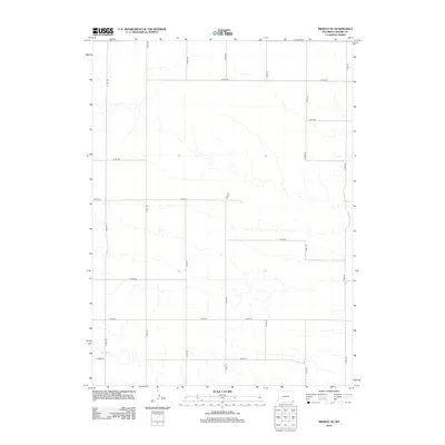
2012 Map of Midway SE
USGS Topo · Published 2012About this map
Spring Cr flows through the southwest corner of this high plains landscape in Laramie County, providing a rare water source in an otherwise arid expanse. The terrain is defined by a rigorous grid of section-line roads, such as Co Rd 149 and Co Rd 150, which reflect the late-20th-century development of Wyoming’s rural infrastructure. This 2012 survey by the U.S. Geological Survey details a landscape shaped by both natural drainage patterns and the heavy hand of the Public Land Survey System. Genealogists and historians can trace the connectivity of this region via thoroughfares like Co Rd 218 and Co Rd 225, which link scattered ranchlands and agricultural holdings. The map serves as a clear record of the area's rural transition, showing the intersection of local routes like Co Rd 153 and Co Rd 154 at the eastern edge of the quadrangle.
Find a feature on this map
16 named features on this map. Tap any name to fly to it.
Don’t see what you’re looking for? This feature index may not catch every label — zoom into the map to look around manually.
Map Details
Editions of this 2012 Midway SE Map
This is the sole edition of this map. No revisions or reprints were ever made.
Other maps of this area

1954 · Cheyenne
USGS Topo · 1:250,000

1958 · Cheyenne
USGS Topo · 1:250,000

1963 · Burns
USGS Topo · 1:24,000

1963 · Midway
USGS Topo · 1:24,000

1963 · Midway SE
USGS Topo · 1:24,000
1963 · Round Top
USGS Topo · 1:24,000

1963 · Midway SW
USGS Topo · 1:24,000
1963 · Hillsdale
USGS Topo · 1:24,000

1963 · Gurney Peak
USGS Topo · 1:24,000

1963 · Tracy
USGS Topo · 1:24,000