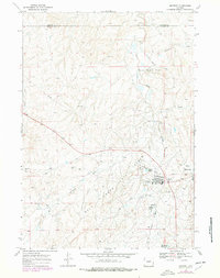
1968 Map of Midwest
USGS Topo · Published 1978About this map
The energy-driven landscape of central Wyoming is defined here by the Shannon Pool Oil Field and the surrounding industrial infrastructure. Centered on the company towns of Midwest and Edgerton, the area is a dense network of extraction and processing, featuring a large Gas Plant and associated Gas Plant Camp. While the industrial footprint is heavy, the map also captures the community life of the workers, including a Golf Course, Athletic Field, and Rodeo Ground near the residential sectors.
Find a feature on this map
28 named features on this map. Tap any name to fly to it.
Don’t see what you’re looking for? This feature index may not catch every label — zoom into the map to look around manually.
Map Details
Editions of this 1968 Midwest Map
2 editions found
Other maps of this area

1954 · Linch
USGS Topo · 1:24,000

1955 · Arminto
USGS Topo · 1:250,000

1958 · Arminto
USGS Topo · 1:250,000

1959 · Edgerton
USGS Topo · 1:62,500

1961 · Dugout Ranch
USGS Topo · 1:24,000

1961 · Dead Woman Crossing
USGS Topo · 1:24,000

1962 · Arminto
USGS Topo · 1:250,000

1968 · Big Gulch
USGS Topo · 1:24,000

1968 · Midwest
USGS Topo · 1:24,000

1968 · Salt Creek
USGS Topo · 1:24,000