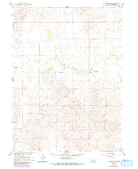
1960 Map of Mignery Ranch
USGS Topo · Published 1993About this map
Beaver Creek meanders through the heart of this Wheeler County landscape, which is defined by the large-scale ranching operations that characterize this portion of the Nebraska sandhills. During the mid-twentieth century, life in this region centered around established homesteads like the Mignery Ranch and Koinzan Ranch. The presence of the Wayside Sch reflects the small, community-based educational infrastructure required for these relatively isolated ranching families. This map illustrates a transition in land use, where revisions from the early 1980s highlight changing woodland cover and fence lines within the traditional grazing territories of the Day Ranch and Headquarters Ranch. The intricate contour lines depict the rolling topography of the hills, emphasizing the relationship between water sources and settlement patterns in an area where stable ranching headquarters were the primary anchors of the local economy.
Find a feature on this map
7 named features on this map. Tap any name to fly to it.
Don’t see what you’re looking for? This feature index may not catch every label — zoom into the map to look around manually.
Map Details
Editions of this 1960 Mignery Ranch Map
3 editions found
Other maps of this area

1954 · Bartlett SE
USGS Topo · 1:24,000

1954 · Bartlett
USGS Topo · 1:24,000

1955 · Broken Bow
USGS Topo · 1:250,000

1955 · O'Neill
USGS Topo · 1:250,000

1956 · Broken Bow
USGS Topo · 1:250,000

1959 · O'Neill
USGS Topo · 1:250,000

1960 · Spalding 2 SW
USGS Topo · 1:24,000

1960 · Spalding 2 NW
USGS Topo · 1:24,000

1960 · Spalding 2 NE
USGS Topo · 1:24,000

1960 · Spalding 2 SE
USGS Topo · 1:24,000