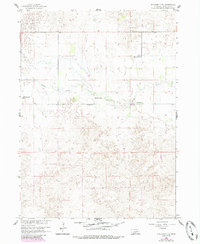
1960 Map of Spalding 2 NW
USGS Topo · Published 1985About this map
Beaver Creek winds through the northern portion of this Nebraska landscape, providing a primary water source for a region dominated by large-scale ranching operations. The mapping of Koinzan Ranch, Mignery Ranch, Headquarters Ranch, and Day Ranch illustrates a pattern of sparse, family-held landholdings characteristic of Wheeler County in the mid-20th century.
Find a feature on this map
7 named features on this map. Tap any name to fly to it.
Don’t see what you’re looking for? This feature index may not catch every label — zoom into the map to look around manually.
Map Details
Editions of this 1960 Spalding 2 NW Map
3 editions found
Other maps of this area

1954 · Bartlett SE
USGS Topo · 1:24,000

1954 · Bartlett
USGS Topo · 1:24,000

1955 · Broken Bow
USGS Topo · 1:250,000

1955 · O'Neill
USGS Topo · 1:250,000

1956 · Broken Bow
USGS Topo · 1:250,000

1959 · O'Neill
USGS Topo · 1:250,000

1960 · Spalding 2 SW
USGS Topo · 1:24,000

1960 · Spalding 2 NW
USGS Topo · 1:24,000

1960 · Spalding 2 NE
USGS Topo · 1:24,000

1960 · Spalding 2 SE
USGS Topo · 1:24,000