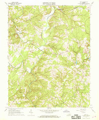
1966 Map of Mike
USGS Topo · Published 1968About this map
The Falling River and its numerous tributaries, including Little Falling River and South Fork Falling River, define the rural landscape of southern Virginia at the boundary of Campbell and Appomattox counties. This mid-1960s terrain is marked by a network of country churches and community centers, from Hat Creek Ch in the south to Spring Mills in the north. The small settlement of Mike serves as a central point, situated near St Lukes Ch and Union Hill Ch. The topography rises toward Red Oak Mountain and Gravel Ridge in the west, while the river valleys below are dotted with landmarks like the Falling River Sch and a Gaging Sta. This survey captures the area before modern development, showing a reliance on traditional road networks and Jeep Trails to navigate the creek-carved hills.
Find a feature on this map
31 named features on this map. Tap any name to fly to it.
Don’t see what you’re looking for? This feature index may not catch every label — zoom into the map to look around manually.
Map Details
Editions of this 1966 Mike Map
2 editions found
Other maps of this area

1892 · Lynchburg
USGS Topo · 1:125,000

1892 · Appomattox
USGS Topo · 1:125,000

1944 · Lynchburg
USGS Topo · 1:62,500

1947 · Roanoke
USGS Topo · 1:250,000

1950 · Lynchburg
USGS Topo · 1:62,500

1956 · Brookneal
USGS Topo · 1:62,500

1956 · Gladys
USGS Topo · 1:62,500

1958 · Appomattox
USGS Topo · 1:62,500

1959 · Roanoke
USGS Topo · 1:250,000

1963 · Roanoke
USGS Topo · 1:250,000