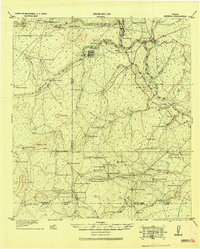
1920 Map of Mikeska
USGS Topo · Published 1920About this map
Oakville and the nearby Three Rivers are central nodes in this South Texas tactical study, situated where the Nueces River and San Antonio river systems converge. The map documents an era of transition for the region, highlighting the emergence of George West and the presence of the San Antonio Uvalde and Gulf Railroad, which was added to the topographic data in late 1918. The landscape is defined by its ranching economy, with dozens of named family holdings such as the O'Connor Ranch, Lyons Ranch, and Byrne Ranch dotting the brush country between hills like San Cajo and the Rosalier Hills.
Find a feature on this map
85 named features on this map. Tap any name to fly to it.
Don’t see what you’re looking for? This feature index may not catch every label — zoom into the map to look around manually.
Map Details
Editions of this 1920 Mikeska Map
This is the sole edition of this map. No revisions or reprints were ever made.
Other maps of this area
1920 · San Diego
USGS Topo · 1:62,500
1925 · Oakville No. 4
USGS Topo · 1:48,000
1925 · Mathis No. 2
USGS Topo · 1:48,000
1925 · Simmons No. 1
USGS Topo · 1:48,000
1925 · Tilden No. 1
USGS Topo · 1:48,000
1925 · Mathis No. 3
USGS Topo · 1:48,000
1925 · Crowther No. 3
USGS Topo · 1:48,000
1925 · Simmons No. 2
USGS Topo · 1:48,000
1927 · Mathis
USGS Topo · 1:62,500
1927 · Oakville
USGS Topo · 1:62,500