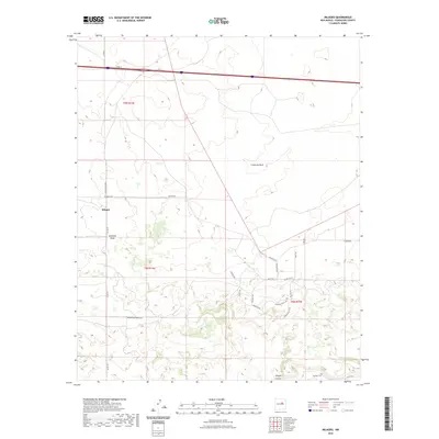
2023 Map of Milagro
USGS Topo · Published 2023About this map
Milagro stands as a focal point in this high-plains landscape of Guadalupe County, where the high desert is carved by deep drainage features like Milagro Canyon and Cañon de Baca. The settlement pattern is defined by a network of ranch roads and rural lanes, such as Encantada Ranch Rd and Mesa de Leon Rd, which navigate the mesas and draws. For genealogists and local historians, the inclusion of the Sombrio Cem in the southern reaches provides a specific point of interest for tracing early family roots in the area. The terrain's natural drainage is marked by Encinosa Draw, illustrating the geographic constraints that have influenced road placement and land use across the t8n r16e, t8n r17e, and t9n r16e townships.
Find a feature on this map
26 named features on this map. Tap any name to fly to it.
Don’t see what you’re looking for? This feature index may not catch every label — zoom into the map to look around manually.
Map Details
Editions of this 2023 Milagro Map
This is the sole edition of this map. No revisions or reprints were ever made.
Other maps of this area

1890 · Bernal
USGS Topo · 1:125,000

1891 · Bernal
USGS Topo · 1:125,000

1894 · Bernal
USGS Topo · 1:125,000

1954 · Santa Fe
USGS Topo · 1:250,000

1954 · Fort Sumner
USGS Topo · 1:250,000

1958 · Fort Sumner
USGS Topo · 1:250,000

1958 · Santa Fe
USGS Topo · 1:250,000
1963 · Thompson Ranch
USGS Topo · 1:24,000
1963 · Mesa Palo Amarillo
USGS Topo · 1:24,000
1963 · Potrillo Hill
USGS Topo · 1:24,000