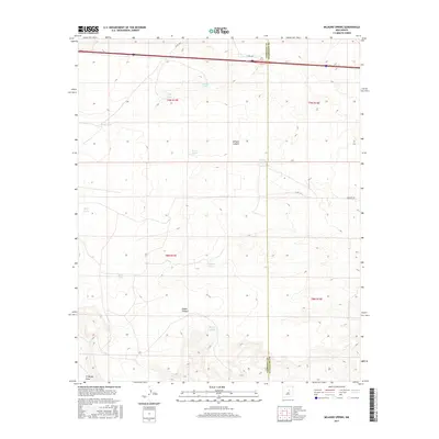
2017 Map of Milagro Spring
USGS Topo · Published 2017About this map
Milagro Spring serves as a central point of interest in this high-desert landscape situated on the border of Torrance and Guadalupe Counties. The area is defined by its strategic water management, featuring a wide distribution of livestock watering points such as Fish Tank, Ardans Tanks, and Bonito Tank that support ranching across the township grids of t9n r15e and t8n r16e. These features illustrate the essential infrastructure required for survival and industry in the arid Southwest. Significant geographical markers like Milagro Canyon and Diablo Canyon break the terrain, while El Marge Draw cuts through the southwestern section. The local road network, including Co RD 4 Fa and Milagro Rd, provides access to these remote landmarks and water sources, tracing the movement of people and livestock through this sparsely populated territory.
Find a feature on this map
21 named features on this map. Tap any name to fly to it.
Don’t see what you’re looking for? This feature index may not catch every label — zoom into the map to look around manually.
Map Details
Editions of this 2017 Milagro Spring Map
This is the sole edition of this map. No revisions or reprints were ever made.
Other maps of this area

1890 · Bernal
USGS Topo · 1:125,000

1891 · Bernal
USGS Topo · 1:125,000

1894 · Bernal
USGS Topo · 1:125,000

1954 · Santa Fe
USGS Topo · 1:250,000

1954 · Fort Sumner
USGS Topo · 1:250,000

1958 · Fort Sumner
USGS Topo · 1:250,000

1958 · Santa Fe
USGS Topo · 1:250,000

1963 · Jacinto Mesa
USGS Topo · 1:24,000
1963 · Mesa Palo Amarillo
USGS Topo · 1:24,000
1963 · Potrillo Hill
USGS Topo · 1:24,000