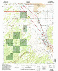
1995 Map of Milan
USGS Topo · Published 1998About this map
The volcanic landscape of The Malpais dominates the eastern half of this mid-1990s survey, where the Rio San Jose winds through lava flows and agricultural land. The village of Milan and the neighboring settlement of Toltec are established along the transportation corridors that border the Cibola National Forest. While modern infrastructure like the Grants Municipal Airport and local golf course serve the growing community, the map reveals a deep reliance on the land through numerous working properties, including the Stanley and Card Ranch, Harding Ranch, and Schneemann Ranch. Water management is a visible priority, with various ditches and a network of canals supporting the valley's ranches. Local history is anchored by the Bluewater Cemetery to the north, while industrial activities like a Sawmill and multiple quarries point to the region's extractive economic roots.
Find a feature on this map
29 named features on this map. Tap any name to fly to it.
Don’t see what you’re looking for? This feature index may not catch every label — zoom into the map to look around manually.
Map Details
Editions of this 1995 Milan Map
This is the sole edition of this map. No revisions or reprints were ever made.
Other maps of this area

1883 · Mt. Taylor
USGS Topo · 1:250,000

1886 · Wingate
USGS Topo · 1:250,000

1886 · Mt. Taylor
USGS Topo · 1:250,000

1892 · Wingate
USGS Topo · 1:250,000

1892 · Mt. Taylor
USGS Topo · 1:250,000

1899 · Mt. Taylor
USGS Topo · 1:250,000

1951 · Mt Sedgwick
USGS Topo · 1:24,000

1952 · Paxton Springs
USGS Topo · 1:24,000

1954 · Gallup
USGS Topo · 1:250,000

1957 · San Rafael
USGS Topo · 1:24,000