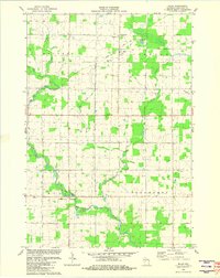
1981 Map of Milan
USGS Topo · Published 1982About this map
The Big Eau Pleine River winds through this central Wisconsin landscape, joined by tributaries like Randall Creek and Marsh Creek. Small rural settlements like Milan and Cherokee serve as local anchors, while the terrain is dotted with several neighborhood burial grounds including St Thomas Cem, Bethlehem Cem, and Pilgrim Rest Cem. This 1981 survey reveals a structured agricultural and industrial grid, defined by the boundaries of Holton, Johnson, Hull, and Frankfort townships. Beyond the farms, the presence of Gravel Pits and the Sewage Disposal Ponds near Milan points to the infrastructure supporting these small communities during the early 1980s. For those looking for recreation, the Wayside Park and County Park provide green spaces near the riverbanks.
Find a feature on this map
21 named features on this map. Tap any name to fly to it.
Don’t see what you’re looking for? This feature index may not catch every label — zoom into the map to look around manually.
Map Details
Editions of this 1981 Milan Map
This is the sole edition of this map. No revisions or reprints were ever made.
Other maps of this area

1902 · Marathon
USGS Topo · 1:125,000

1951 · Athens
USGS Topo · 1:48,000

1951 · Medford
USGS Topo · 1:48,000

1953 · Abbotsford
USGS Topo · 1:48,000

1953 · Stratford
USGS Topo · 1:48,000

1953 · Eau Claire
USGS Topo · 1:250,000

1953 · Rice Lake
USGS Topo · 1:250,000

1958 · Eau Claire
USGS Topo · 1:250,000

1959 · Rice Lake
USGS Topo · 1:250,000

1963 · Stratford
USGS Topo · 1:62,500