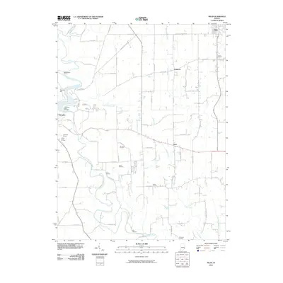
2010 Map of Milan
USGS Topo · Published 2010About this map
Laughery Creek carves a winding path through this portion of Ripley County, defining the western edge of the quadrangle near the community of Versailles. The landscape is a network of small watercourses like Falling Timber Creek and Caesar Creek, which drain the agricultural uplands where scattered settlements such as Elrod and Stringtown are situated. This area is notably dense with small family and community burial grounds, providing significant genealogical data through sites like Marble Corner Cemetery, Craven Cemetery, and Blair Cemetery. To the west, the Versailles State Park Dam and the Versailles Airport represent the more modern infrastructure of the region. The map also documents a complex grid of county roads, including the N Milan Versailles Pike, which serves as a primary transit corridor connecting Milan to the county seat.
Find a feature on this map
60 named features on this map. Tap any name to fly to it.
Don’t see what you’re looking for? This feature index may not catch every label — zoom into the map to look around manually.
Map Details
Editions of this 2010 Milan Map
This is the sole edition of this map. No revisions or reprints were ever made.
Other maps of this area

1946 · Versailles
USGS Topo · 1:24,000

1946 · Milan
USGS Topo · 1:24,000

1946 · Pierceville
USGS Topo · 1:24,000

1946 · Osgood
USGS Topo · 1:24,000

1953 · Cincinnati
USGS Topo · 1:250,000

1956 · Louisville
USGS Topo · 1:250,000

1957 · Cincinnati
USGS Topo · 1:250,000

1958 · Sunman
USGS Topo · 1:24,000

1958 · Dillsboro
USGS Topo · 1:24,000
1959 · Rexville
USGS Topo · 1:24,000