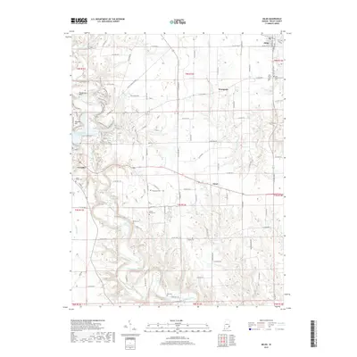
2019 Map of Milan
USGS Topo · Published 2019About this map
Laughery Creek carves a deep, winding valley through the center of this Ripley County landscape, defining the topography between Versailles and Milan. The area's settlement history is etched into the terrain through numerous family and community burial grounds, including the Wilson Family Cem and Marble Corner Cem. Small communities like Elrod and Stringtown anchor the rural road network, which transitions from the structured grid of the uplands to the meandering paths dictated by the creek's steep banks. Near the western edge, the Versailles State Park Dam represents a significant modification of the natural hydrology, while landmarks like Henderson Bend and Hassmer Hill highlight the elevation changes characteristic of this portion of southeastern Indiana. The map provides a detailed view of the rural-to-town transition in the late 2010s.
Find a feature on this map
103 named features on this map. Tap any name to fly to it.
Don’t see what you’re looking for? This feature index may not catch every label — zoom into the map to look around manually.
Map Details
Editions of this 2019 Milan Map
This is the sole edition of this map. No revisions or reprints were ever made.
Other maps of this area

1946 · Versailles
USGS Topo · 1:24,000

1946 · Milan
USGS Topo · 1:24,000

1946 · Pierceville
USGS Topo · 1:24,000

1946 · Osgood
USGS Topo · 1:24,000

1953 · Cincinnati
USGS Topo · 1:250,000

1956 · Louisville
USGS Topo · 1:250,000

1957 · Cincinnati
USGS Topo · 1:250,000

1958 · Sunman
USGS Topo · 1:24,000

1958 · Dillsboro
USGS Topo · 1:24,000
1959 · Rexville
USGS Topo · 1:24,000