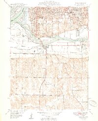
1950 Map of Milan
USGS Topo · Published 1950About this map
Black Hawk State Park anchors the confluence of the Mississippi River and Rock River, illustrating the complex water-and-rail geography of the Illinois-Iowa border just after the war. The map reveals an intensive network of educational and social institutions serving the expanding cities of Rock Island and Moline, including the County Sanitarium and numerous neighborhood schools like Denkman Sch and Logan Sch. South of the rivers, the landscape transitions from the urbanized riverbanks to the more dispersed settlements of Milan and Fruitland. Local history is preserved in the clustering of denominational cemeteries such as St Mary Cem, Calvary Cem, and Hebrew Cem on the heights of South Rock Island. Further south, the path of the Rock Island Southern and an Abandoned Railroad mark the changing industrial footprint of the Coal Valley region.
Find a feature on this map
64 named features on this map. Tap any name to fly to it.
Don’t see what you’re looking for? This feature index may not catch every label — zoom into the map to look around manually.
Map Details
Editions of this 1950 Milan Map
2 editions found

Other maps of this area

1891 · Davenport
USGS Topo · 1:62,500

1892 · Leclaire
USGS Topo · 1:62,500

1893 · Leclaire
USGS Topo · 1:62,500

1894 · Davenport
USGS Topo · 1:62,500

1899 · Clinton
USGS Topo · 1:125,000

1901 · Rock Island
USGS Topo · 1:125,000

1910 · Rock Island
USGS Topo · 1:125,000

1912 · Milan
USGS Topo · 1:62,500

1937 · Orion
USGS Topo · 1:62,500

1944 · Milan
USGS Topo · 1:62,500