1935 Map of Miles
USGS Topo · Published 1957About this map
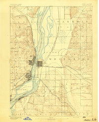
The Savanna Ordnance Depot dominates the riverfront landscape in this 1930s survey, marking a significant military footprint along the Mississippi River corridor. The map captures a moment of transition where industrial and military utility meets the complex riparian environment of the driftless region. Along the Chicago Burlington and Quincy railroad, the small settlement of Whitton serves as a local waypoint, while the rural education system is evidenced by the Nobis Sch and Lost Mound Sch. The intricate hydrology of the area is well-documented through the winding path of the Apple River and a series of numbered islands, including Island No 254 and Island No 257, which flank the Crooked Slough. Large portions of the map remain an Unsurveyed Area, contrasting the detailed river topography with the unknown interiors of the mid-1930s.
Find a feature on this map
15 named features on this map. Tap any name to fly to it.
Don’t see what you’re looking for? This feature index may not catch every label — zoom into the map to look around manually.
Map Details
Editions of this 1935 Miles Map
This is the sole edition of this map. No revisions or reprints were ever made.
Other maps of this area

1891 · DeWitt
USGS Topo · 1:62,500
1891 · Maquoketa
USGS Topo · 1:62,500

1891 · Clinton
USGS Topo · 1:62,500

1892 · Goose Lake
USGS Topo · 1:62,500

1892 · Savanna
USGS Topo · 1:62,500
1894 · Goose Lake
USGS Topo · 1:62,500
1894 · Clinton
USGS Topo · 1:62,500

1899 · Clinton
USGS Topo · 1:125,000

1901 · Peosta
USGS Topo · 1:125,000

1901 · Rock Island
USGS Topo · 1:125,000