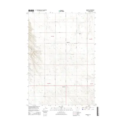
2015 Map of Milesville
USGS Topo · Published 2015About this map
Milesville and Billsburg anchor this segment of the Haakon County high plains, where the open landscape is defined by the drainage of Harding Cr and Straighthead Cr. This 2015 topography shows a rural landscape meticulously organized by the Public Land Survey System, with gravel roads like Milesville Rd and Kings School Rd following section lines across the broad Milesville Flat. For genealogists and local historians, the map identifies specific points of historical continuity, including the Milesville Cem and the Topbar Cem further south. The drainage patterns of E Fork Spotted Bear Cr in the west contrast with the more level grazing lands to the east, illustrating the subtle but essential water resources that have shaped ranching and settlement in this part of South Dakota for generations.
Find a feature on this map
24 named features on this map. Tap any name to fly to it.
Don’t see what you’re looking for? This feature index may not catch every label — zoom into the map to look around manually.
Map Details
Editions of this 2015 Milesville Map
This is the sole edition of this map. No revisions or reprints were ever made.
Other maps of this area

1954 · Pierre
USGS Topo · 1:250,000

1955 · Rattlesnake Lake SE
USGS Topo · 1:24,000

1955 · Rattlesnake Lake SW
USGS Topo · 1:24,000

1955 · Bridger SE
USGS Topo · 1:24,000

1958 · Pierre
USGS Topo · 1:250,000

1983 · Philip
USGS Topo · 1:100,000

1983 · Hilland
USGS Topo · 1:24,000
1983 · Hartley
USGS Topo · 1:24,000

1983 · Milesville
USGS Topo · 1:24,000

1983 · Tornado Ranch
USGS Topo · 1:24,000