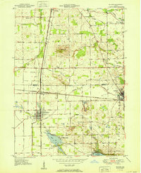
1951 Map of Milford
USGS Topo · Published 1951About this map
Milford and Syracuse anchor this mid-century survey of the northern Indiana prairie, a landscape defined by an intricate network of drainage ditches and intersecting rail lines. The Baltimore And Ohio and the New York Central railroads cross at Milford Junction, illustrating the region's importance as a midwestern transit hub. To the north, the Elkhart River and Solomon Creek meander through the farmland, while the southern portion of the map is dominated by the waters of Wabee Lake and Dewart Lake.
Find a feature on this map
40 named features on this map. Tap any name to fly to it.
Don’t see what you’re looking for? This feature index may not catch every label — zoom into the map to look around manually.
Map Details
Editions of this 1951 Milford Map
2 editions found
Other maps of this area

1950 · Leesburg
USGS Topo · 1:24,000

1950 · North Webster
USGS Topo · 1:24,000

1951 · Milford
USGS Topo · 1:24,000

1951 · Wawasee
USGS Topo · 1:24,000

1953 · Fort Wayne
USGS Topo · 1:250,000

1956 · Fort Wayne
USGS Topo · 1:250,000

1958 · Nappanee East
USGS Topo · 1:24,000

1959 · Atwood
USGS Topo · 1:24,000

1959 · Millersburg
USGS Topo · 1:24,000

1959 · Goshen
USGS Topo · 1:24,000