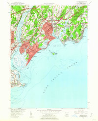
1951 Map of Milford
USGS Topo · Published 1960About this map
The Housatonic River forms a natural divide between Fairfield and New Haven counties, serving as the backdrop for early 1950s coastal development. The New York New Haven and Hartford railroad tracks traverse the landscape, meeting at Naugatuck Junction just north of the Washington Bridge. Coastal life is defined by a sequence of beaches and points, from Milford Pt to Silver Beach, while Charles Island sits prominently in The Gulf.
Find a feature on this map
85 named features on this map. Tap any name to fly to it.
Don’t see what you’re looking for? This feature index may not catch every label — zoom into the map to look around manually.
Map Details
Editions of this 1951 Milford Map
3 editions found
Other maps of this area

1889 · Derby
USGS Topo · 1:62,500

1891 · Bridgeport
USGS Topo · 1:62,500

1891 · Derby
USGS Topo · 1:62,500

1892 · New Haven
USGS Topo · 1:62,500

1893 · Bridgeport
USGS Topo · 1:62,500

1893 · Derby
USGS Topo · 1:62,500

1920 · Bridgeport
USGS Topo · 1:62,500

1921 · New Haven
USGS Topo · 1:62,500

1943 · New Haven
USGS Topo · 1:31,680
1947 · Long Hill
USGS Topo · 1:31,680