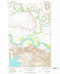
1972 Map of Milk River Hills
USGS Topo · Published 1975About this map
The Missouri River and its tributary, the Milk River, dominate this Northern Montana landscape, carving deep loops through the terrain just north of the Charles M Russell National Wildlife Range. The convergence of these waters defines a complex network of coulees and hills, including the prominent Deadman Butte and the winding Milk Coulee Bay of Fort Peck Lake. The map illustrates a landscape of working cattle ranches and infrastructure, marked by the Nickels Ranch and its adjacent Nickels Landing Strip.
Find a feature on this map
30 named features on this map. Tap any name to fly to it.
Don’t see what you’re looking for? This feature index may not catch every label — zoom into the map to look around manually.
Map Details
Editions of this 1972 Milk River Hills Map
This is the sole edition of this map. No revisions or reprints were ever made.
Other maps of this area

1914 · Nashua
USGS Topo · 1:62,500

1915 · Frazer
USGS Topo · 1:62,500

1916 · Nashua
USGS Topo · 1:62,500

1954 · Jordan
USGS Topo · 1:250,000

1954 · Glasgow
USGS Topo · 1:250,000

1956 · Jordan
USGS Topo · 1:250,000

1957 · Glasgow
USGS Topo · 1:250,000

1958 · Glasgow
USGS Topo · 1:250,000

1958 · Jordan
USGS Topo · 1:250,000

1964 · Jordan
USGS Topo · 1:250,000