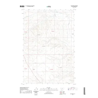
2020 Map of Milk Springs
USGS Topo · Published 2020About this map
Milk Springs serves as a central landmark in this portion of Fergus County, where the high plains terrain is defined by a network of drainage systems and isolated elevations. Significant ridges and peaks like Button Butte and Bald Butte break the horizon, while the southern reaches feature the distinct Three Buttes. The landscape is carved by numerous coulees and seasonal waterways, including the upper reaches of Yellow Water Cr and its tributaries, as well as the north-flowing N Fork Elk Cr. The map documents a sparsely populated ranching landscape, where long-established routes such as Battrick Rd and Elk Creek Rd provide access through the complex topography of Tennessee Flat and the deep incisions of Kinnick Coulee. This layout reflects a quintessential Central Montana geography of high plateaus and vital spring locations.
Find a feature on this map
21 named features on this map. Tap any name to fly to it.
Don’t see what you’re looking for? This feature index may not catch every label — zoom into the map to look around manually.
Map Details
Editions of this 2020 Milk Springs Map
This is the sole edition of this map. No revisions or reprints were ever made.
Other maps of this area

1954 · Roundup
USGS Topo · 1:250,000

1954 · Lewistown
USGS Topo · 1:250,000

1958 · Roundup
USGS Topo · 1:250,000

1959 · Lewistown
USGS Topo · 1:250,000

1986 · Tyler
USGS Topo · 1:24,000

1986 · Snoose Creek
USGS Topo · 1:24,000

1986 · Briggs Coulee
USGS Topo · 1:24,000

1986 · Pike Creek Hills West
USGS Topo · 1:24,000

1986 · Pike Creek Hills East
USGS Topo · 1:24,000
1986 · Grass Range
USGS Topo · 1:24,000