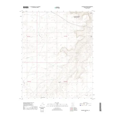
2018 Map of Milkweed Canyon NW
USGS Topo · Published 2018About this map
Lake Mead National Recreation Area spans the northern reaches of this Mohave County landscape, where the high desert plateau is carved by deep drainage systems. The namesake Milkweed Canyon and Spencer Canyon dominate the topography, revealing a network of water management features essential for the arid environment. A series of specialized water catchments, including Meriwhitica Tank, Steel Tank, and Willow Tank, are distributed across the terrain, connected by backcountry routes such as Meriwhitica Rd and Buck and Doe Rd. These features, alongside Harding Spring and Willow Spring, illustrate the historical reliance on isolated water sources for ranching or travel through this remote portion of Arizona. The map serves as a detailed guide to these hydrological landmarks and the rugged canyons that define the region's character.
Find a feature on this map
17 named features on this map. Tap any name to fly to it.
Don’t see what you’re looking for? This feature index may not catch every label — zoom into the map to look around manually.
Map Details
Editions of this 2018 Milkweed Canyon NW Map
This is the sole edition of this map. No revisions or reprints were ever made.
Other maps of this area

1886 · Diamond Creek
USGS Topo · 1:250,000

1892 · Diamond Creek
USGS Topo · 1:250,000

1948 · Williams
USGS Topo · 1:250,000

1954 · Williams
USGS Topo · 1:250,000

1956 · Williams
USGS Topo · 1:250,000

1960 · Williams
USGS Topo · 1:250,000

1961 · Williams
USGS Topo · 1:250,000
1967 · Milkweed Canyon SE
USGS Topo · 1:24,000

1967 · Milkweed Canyon SW
USGS Topo · 1:24,000
1967 · Milkweed Canyon NW
USGS Topo · 1:24,000