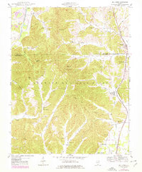
1947 Map of Mill Creek
USGS Topo · Published 1978About this map
Shawnee National Forest covers much of this landscape at the border of Union and Alexander Counties, where rugged topography is punctuated by numerous family-named landmarks and rural institutions. Small settlements like Mill Creek and Elco are linked by the Gulf Mobile and Ohio railroad and the Central rail line, which trace the valleys alongside Hartline Creek. The map reveals a dense network of early 20th-century social hubs, including the Valley Mission church and schools such as Lylerle Sch and Delta Sch.
Find a feature on this map
48 named features on this map. Tap any name to fly to it.
Don’t see what you’re looking for? This feature index may not catch every label — zoom into the map to look around manually.
Map Details
Editions of this 1947 Mill Creek Map
2 editions found
Other maps of this area

1920 · Jonesboro
USGS Topo · 1:62,500

1920 · Dongola
USGS Topo · 1:62,500

1923 · Dongola
USGS Topo · 1:62,500

1923 · Jonesboro
USGS Topo · 1:62,500

1931 · Cairo
USGS Topo · 1:62,500

1933 · Cairo
USGS Topo · 1:62,500

1934 · Thebes
USGS Topo · 1:62,500

1939 · Cairo
USGS Topo · 1:62,500

1939 · Thebes
USGS Topo · 1:62,500

1947 · Jonesboro
USGS Topo · 1:62,500