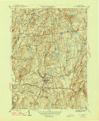
1947 Map of Millbrook
USGS Topo · Published 1947About this map
Millbrook serves as the central hub of this mid-century portrait of Dutchess County, where the village is flanked by the campuses of Bennett Jr College and the Nine Partners Cem. The landscape is a mix of agricultural valley bottoms and prominent ridges like Chestnut Ridge and The Hogback, with numerous small water bodies including Upton Lake and Shaw Pond dotting the terrain. The presence of the County Home near Round Hill and scattered rural schoolhouses such as the Littlerest Sch points to a well-established social infrastructure serving the surrounding townships of Stanford and Washington. Small settlements like Stanfordville, Bangall, and Mabbettsville are connected by a network of local roads following the drainage of Wappinger Creek and its branches, reflecting a post-war era before significant suburban expansion altered these historic crossroads.
Find a feature on this map
34 named features on this map. Tap any name to fly to it.
Don’t see what you’re looking for? This feature index may not catch every label — zoom into the map to look around manually.
Map Details
Editions of this 1947 Millbrook Map
2 editions found
Other maps of this area

1893 · Clove
USGS Topo · 1:62,500

1893 · Poughkeepsie
USGS Topo · 1:62,500

1894 · Clove
USGS Topo · 1:62,500

1894 · Poughkeepsie
USGS Topo · 1:62,500

1898 · Clove
USGS Topo · 1:62,500

1898 · Rhinebeck
USGS Topo · 1:62,500

1899 · Millbrook
USGS Topo · 1:62,500

1901 · Clove
USGS Topo · 1:62,500

1902 · Millbrook
USGS Topo · 1:62,500

1903 · Poughkeepsie
USGS Topo · 1:62,500